Digital Transformation in Mining with GIS: Optimizing Geospatial Data for Operational Efficiency
- Marketing SWG
- Mar 17
- 2 min read

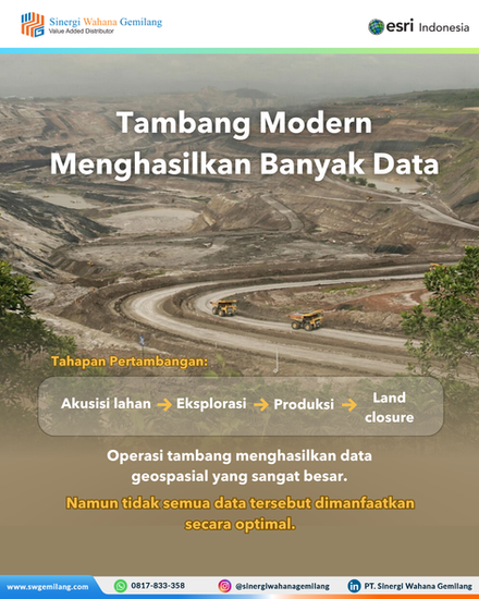


The modern mining industry is not lacking data—quite the opposite. With advancements in technologies such as drone mapping, satellite imagery, and production sensors, the volume of geospatial data continues to grow exponentially. However, without an integrated system, this data often fails to deliver meaningful value for operations.
This is where Geographic Information Systems (GIS) play a critical role in enabling digital transformation across mining operations.
Challenges in Managing Geospatial Data in Mining
In practice, many mining companies struggle to manage geospatial data effectively. Data collected from multiple sources is often stored in separate systems, making it difficult to analyze and utilize for decision-making.
As a result, operational challenges frequently arise, including land boundary conflicts, inaccurate topographic data, and errors in mine planning. These issues can even emerge early in the project lifecycle, such as during land acquisition, before production begins.
Despite having access to large volumes of data—from geological surveys to production metrics—the lack of centralized visualization and integration prevents organizations from fully leveraging their data assets.
Dynamic Mining Operations Require Integrated Systems
Mining operations are inherently dynamic. Conditions change daily—pits expand, hauling routes shift, stockpiles increase, and blasting areas move.
Without location-based monitoring systems, these changes can lead to operational inefficiencies, increased costs, and a higher risk of decision-making errors.
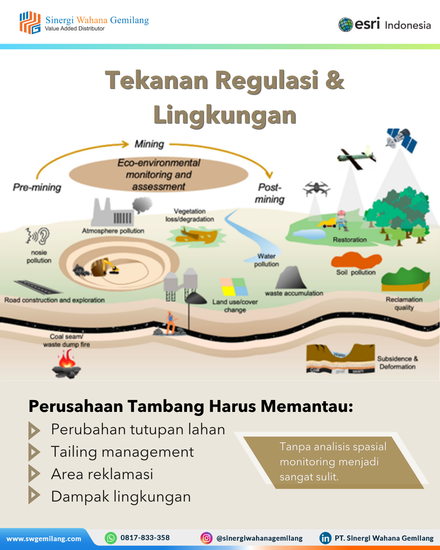
At the same time, mining companies face increasing pressure from environmental and regulatory requirements. Monitoring land cover changes, managing tailings, tracking reclamation areas, and assessing environmental impact become significantly more complex without accurate spatial analysis.
The Role of GIS in Enhancing Efficiency and Control
Implementing GIS solutions for mining allows companies to integrate all geospatial data into a centralized platform. This approach provides better visibility across operations and enables more effective coordination.
With GIS, organizations can improve operational efficiency by optimizing land use and resource management. Environmental monitoring becomes more accurate and consistent, helping companies meet compliance requirements.
More importantly, GIS enables data-driven decision-making by delivering real-time insights, allowing management to respond quickly and effectively to changing conditions.
Toward Structured and Sustainable Digital Mining
Digital transformation in mining is no longer optional—it is a strategic necessity to remain competitive and sustainable. By leveraging GIS technology and geospatial systems, companies can transform fragmented data into valuable strategic assets.
This approach not only enhances operational efficiency but also improves planning accuracy, risk management, and long-term environmental sustainability.
As a Value Added Partner (VAP), PT Sinergi Wahana Gemilang delivers GIS solutions designed to help mining companies optimize operations, improve data visibility, and support more accurate decision-making.
Interested in optimizing your mining operations with GIS solutions?
🌐 www.swgemilang.com📩 marketing@swgemilang.com📱 +62 817-833-358


